

Washington County is committed to being a responsible steward of the environment when constructing and maintaining streets.
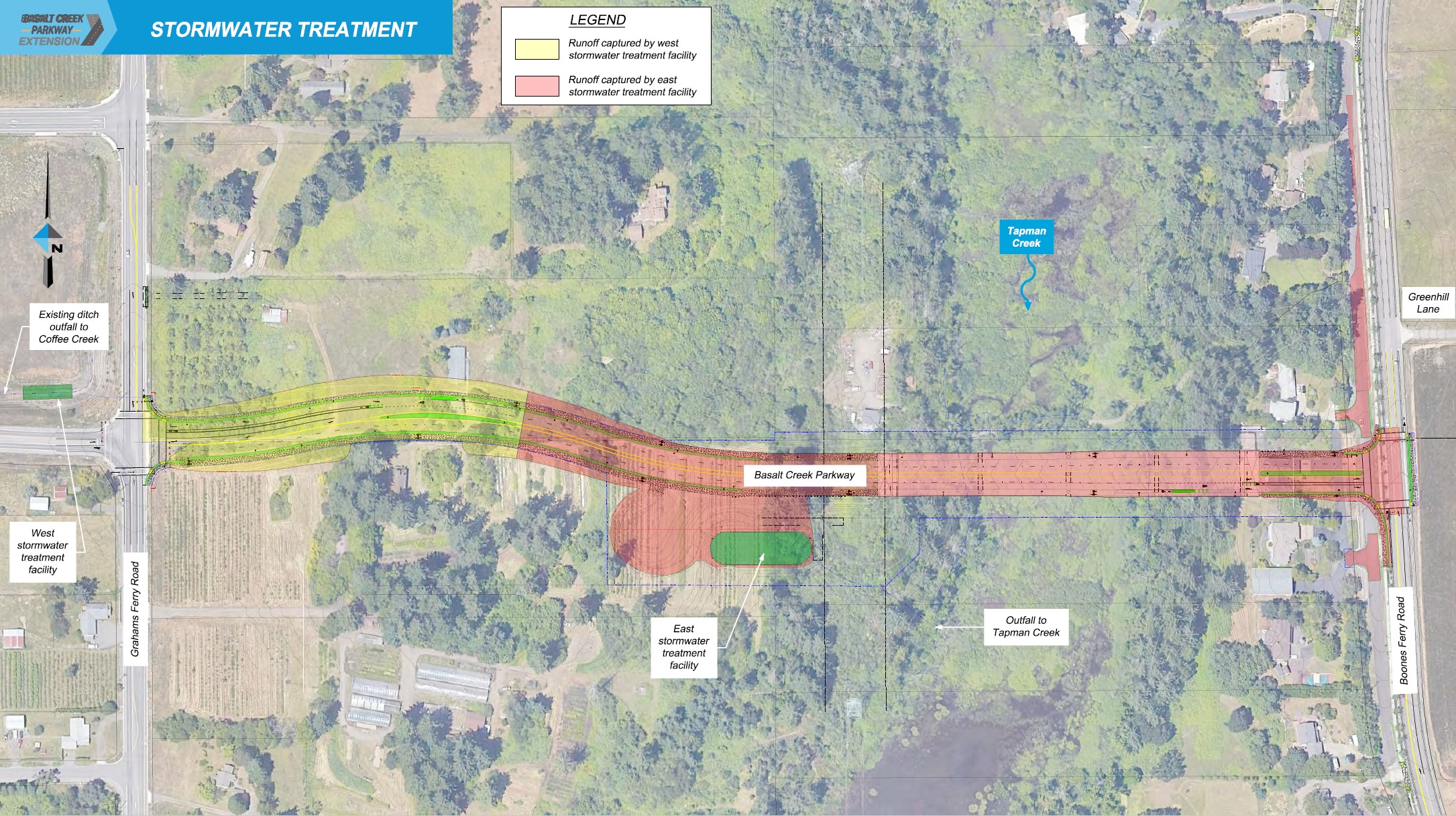
This map shows where stormwater runoff from the street and bridge will be collected and treated to remove contaminants before the water is released into the adjacent creeks. Water runoff from the west portion of the street will be collected at the west stormwater treatment area, on the west side of Grahams Ferry Road. The remaining runoff will be collected in a new east stormwater treatment facility on the south side of the new street extension.
A number of environmental studies and reports are being prepared for this project. Below are reports that have been completed or are still underway. We upload completed reports to the project website as they become available. If you have not subscribed, and would like to receive notification of these uploads, please sign up here.
This report identifies protected and invasive plants and animals of concern in the project area.
No species protected under the Endangered Species Act were found in the project area. Work in or immediately adjacent to the creek will be restricted to July 15-Oct. 30 to minimize impacts to resident fish. We will use Best Management Practices to minimize and restore any environmental impacts that occur during construction.
Much of the existing vegetation in the project area is invasive. Vegetation removed during construction will be replaced with native species at a minimum ratio of one-for-one. About three acres of native plant seeds will be added next to the street. To minimize the spread of invasive species, the project area will receive weed control treatment, and construction equipment will be cleaned of plant material. Restoration or creation of new wetland areas will be required for impacts to existing wetlands and waters.
The project area was reviewed by independent scientists, and endangered species are not present. The project has completed a Determination of No Effect memo.
A study was conducted to determine the location and limits of wetlands within the project area. The project has been designed to span and minimize impacts to environmentally sensitive areas, including Tapman Creek and the adjacent wetlands. The project will use Best Management Practices during construction to help minimize impacts, and will also enhance surrounding wetlands and rehabilitate any temporary impacts which may occur. Enhancements could include the creation and renewing of native ecosystems to sites where they once existed, or enhancing existing degraded ecosystems.
As noted above, all stormwater runoff from the street and bridge will be captured and treated to eliminate contaminates before being released into the adjacent creeks.
This report reviews the noise impacts expected from the new street and is used to determine whether noise reduction is feasible and if the cost is reasonable to build sound walls. The walls should be both feasible and reasonable to be constructed as part of the project.
When considering sound walls, noise-sensitive locations are examined to determine if there will be a significant increase in noise. A significant increase occurs when the sound level increases by at least 10 decibels (dBA). Federal Highway Administration and the Oregon Department of Transportation (ODOT) have published criteria for acceptable noise levels, depending on the use of the land. If a location analyzed exceeds the acceptable level, or if a significant increase occurs at a location, the location is considered impacted.
A sound wall is considered feasible if it achieves at least a 5 dBA reduction in noise levels at the majority of impacted locations.
A 16-foot-high sound wall along the entire length of the project provided the required noise reduction at the majority of impacted locations and therefore met the feasibility criteria.
Sound walls are considered reasonable if the cost per benefitted property owner is less than $25,000 according to ODOT guidelines. The cost per property impacted by this project significantly exceeds that amount. On the north side of the street, it would cost $267,000 per property owner. On the south side of the street, it would cost $114,000 per property owner.
The report recommends that we do not build noise walls for this project. This recommendation is based on the findings that the cost of the walls far exceeds what is considered reasonable per federal and ODOT guidance for each benefitted property owner. In addition, most of the adjacent properties are zoned for future industrial and employment development, which are not considered noise-sensitive land use categories. Sound walls are not recommended on this project.
The bridge spanning Tapman Creek will be supported by three sets of columns (see design map). Geotechnical investigations are complete and a report is in progress. Investigations showed that bridge foundations can be constructed at the proposed locations. The report provides guidance on the design of bridge foundations and a retaining wall at the west end of the bridge to minimize impacts to sensitive areas and adjacent properties.
Report not yet available